Posts

Showing posts from July, 2012

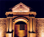
Historic Town of Grand-Bassam Ivory Coast

Image
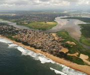
The first capital of Ivory Coast, the Historic Town of Grand-Bassam, is an example of a late 19th- and early 20th-century colonial town planned with quarters specializing in commerce, administration, housing for Europeans and for Africans. The site includes the N'zima African fishing village alongside colonial architecture marked by functional houses with galleries, verandas and gardens. Grand-Bassam was the most important port, economic and judicial centre of Côte d'Ivoire. It bears witness to the complex social relations between Europeans and Africans, and to the subsequent independence movement. As a vibrant centre of the territory of French trading posts in the Gulf of Guinea, which preceded modern Côte d'Ivoire, it attracted populations from all parts of Africa, Europe and the Mediterranean Levant. Continent: Africa Country: Ivory Coast Category: Cultural Criterion: (III)(IV) Date of Inscription: 2012

Heritage of Mercury Almaden and Idrija the mining sites

Image
Heritage of Mercury Almaden and Idrija are the mining sites of Almaden (Spain), where mercury (quicksilver) has been extracted since antiquity, and Idrija (Slovenia), where mercury was first found in AD1490. The Spanish property includes buildings relating to its mining history, including Retamar Castle, religious buildings and traditional dwellings. The site in Idrija notably features mercury stores and infrastructure, as well as miners' living quarters, and a miners' theatre. The sites bear testimony to the intercontinental trade in mercury which generated important exchanges between Europe and America over the centuries. Together they represent the two largest mercury mines in the world, operational until recent times. Continent: Europe Country: Slovenia, Spain Category: Cultural Criterion: (II)(IV) Date of Inscription: 2012

Konso Cultural Landscape Ethiopia

Image
Konso Cultural Landscape is a 55km2 arid properties of stone walled terraces and fortified settlements in the Konso highlands of Ethiopia. It constitutes a spectacular example of a living cultural tradition stretching back 21 generations (more than 400 years) adapted to its dry hostile environment. The landscape demonstrates the shared values, social cohesion and engineering knowledge of its communities. The site also features anthropomorphic wooden statues - grouped to represent respected members of their communities and particularly heroic events - which are an exceptional living testimony to funerary traditions that are on the verge of disappearing. Stone steles in the towns express a complex system of marking the passing of generations of leaders. Continent: Africa Country: Ethiopia Category: Cultural Criterion: (III)(IV) Date of Inscription: 2011

Cultural Landscape of Bali Province

Image
The cultural landscape of Bali consists of five rice terraces and their water temples that cover 19,500 ha. The temples are the focus of a cooperative water management system of canals and weirs, known as subak, that dates back to the 9th century. Included in the landscape is the 18th-century Royal Water Temple of Pura Taman Ayun, the largest and most impressive architectural edifice of its type on the island. The subak reflects the philosophical concept of Tri Hita Karana, which brings together the realms of the spirit, the human world and nature. This philosophy was born of the cultural exchange between Bali and India over the past 2,000 years and has shaped the landscape of Bali. The subak system of democratic and egalitarian farming practices has enabled the Balinese to become the most prolific rice growers in the archipelago despite the challenge of supporting a dense population. Continent: Asia Country: Indonesia Category: Cultural Criterion: (II)(III) (V) (VI) Da

Archaeological Sites of the Island of Meroe Sudan

Image
The Archaeological Sites of the Island of Meroe, a semi-desert landscape between the Nile and Atbara rivers, was the heartland of the Kingdom of Kush, a major power from the 8th century B.C. to the 4th century A.D. The property consists of the royal city of the Kushite kings at Meroe, near the River Nile, the nearby religious site of Naqa and Musawwarat es Sufra. It was the seat of the rulers who occupied Egypt for close to a century and features, among other vestiges, pyramids, temples and domestic buildings as well as major installations connected to water management. Their vast empire extended from the Mediterranean to the heart of Africa, and the property testifies to the exchange between the art, architectures, religions and languages of both regions. Continent: Africa Country: Sudan Category: Cultural Criterion: (II)(III) (IV) (V) Date of Inscription: 2011

Chengjiang Fossil Site China

Image
The Chengjiang Fossil Site, located in the Province of Yunnan, China, conserves fossil remains which are of exceptional significance. A hilly 512-hectare site in Yunnan Province, Chengjiang's fossils present the most complete record of an early Cambrian marine community with exceptionally preserved biota, displaying the anatomy of hard and soft tissues in a very wide variety of organisms, invertebrate and vertebrate. They record the early establishment of a complex marine ecosystem. The site documents at least 16 phyla and a variety of enigmatic groups as well as about 196 species, presenting exceptional testimony to the rapid diversification of life on Earth 530 million years ago, when almost all of today's major animal groups emerged. It opens a palaeobiological window of great significance to scholarship. Continent: Asia Country: China Category: Natural Criterion: (VIII) Date of Inscription: 2012

Decorated Farmhouses of Halsingland Heritage

Image
Seven timber houses are listed in this site located in the east of Sweden, representing the zenith of a regional timber building tradition that dates back to the middle Ages. Decorated Farmhouses of Halsingland reflect the prosperity of independent farmers who used their wealth in the 19th century to build substantial new homes with elaborately decorated ancillary houses or suites of rooms reserved for festivities. The paintings represent a fusion of folk art with the styles favoured by the landed gentry of the time, including Baroque and Rococo. Decorated by painters, including known and unknown itinerant artists, the listed properties represent the final flowering of a long cultural tradition. Continent: Europe Country: Sweden Category: Cultural Criterion: (V) Date of Inscription: 2012

Lord Howe Island Group Heritage

Image
Lord Howe Island a remarkable example of isolated oceanic islands, born of volcanic activity more than 2,000 m under the sea, these islands boast a spectacular topography and are home to numerous endemic species, especially birds. Located in the South Pacific, 700 km north-east of Sydney, the property is included administratively in New South Wales. The preserve includes some 75% of the land area of Lord Howe Island and all of the offshore islands and rocks of significant size in the region. These are the Admiralty Group; Mutton Bird and Sail Rock; Blackburn (Rabbit) Island; Gower Island; and Ball's Pyramid, together with a number of small islands and rocks. The seaward boundary follows the mean high water mark and consequently excludes all littoral and marine areas. The entire island group has remarkable volcanic exposures not known elsewhere. Continent: Oceania Country: Australia Category: Natural Criterion: (VII)(X) Date of Inscription: 1982

Lakes of Ounianga Chad

Image
The Lakes of Ounianga includes 18 interconnected lakes in the hyper arid Ennedi region of the Sahara Desert covering an area of 62,808 hectares. It constitutes an exceptional natural landscape of great beauty with striking colours and shapes. The saline, hyper saline and freshwater lakes are supplied by groundwater and are found in two groups 40 kilometres apart. Ounianga Kebir comprises four lakes the largest of which, Yoan, covers an area of 358 hectares and is 27 metres deep. Its highly saline waters only sustain algae and some microorganisms. The second group, Ounianga Serir, comprises 14 lakes separated by sand dunes. Floating reeds cover almost half the surface of these lakes reducing evaporation. At 436 hectares, Lake Teli has the largest surface area but is less than ten metres deep. With their high quality freshwater, some of these lakes are home to aquatic fauna, particularly fish. Continent: Africa Country: Chad Category: Natural Criterion: (VII) Date of Insc

The Kenya Lake System in the Great Rift Valley Heritage

Image
The Kenya Lake System in the Great Rift Valley, a natural property of outstanding beauty, comprises three inter-linked relatively shallow lakes (Lake Bogoria, Lake Nakuru and Lake Elementaita) in the Rift Valley Province of Kenya and covers a total area of 32,034 hectares. The property is home to 13 globally threatened bird species and some of the highest bird diversities in the world. It is the single most important foraging site for the lesser flamingo anywhere, and a major nesting and breeding ground for great white pelicans. The property features sizeable mammal populations, including black rhino, Rothschild's giraffe, greater kudu, lion, cheetah and wild dogs and is valuable for the study of ecological processes of major importance. Continent: Africa Country: Kenya Category: Natural Criterion: (VI)(IX) (X) Date of Inscription: 2011

Prehistoric Pile dwellings around the Alps

Image
This serial property of 111 small individual sites encompasses the remains of prehistoric pile-dwelling settlements in and around the Alps built from around 5000 to 500 B.C. on the edges of lakes, rivers or wetlands. Excavations, only conducted in some of the sites, have yielded evidence that provides insight into life in prehistoric times during the Neolithic and Bronze Age in Alpine Europe and the way communities interacted with their environment. Fifty-six of the sites are located in Switzerland. The settlements are a unique group of exceptionally well-preserved and culturally rich archaeological sites, which constitute one of the most important sources for the study of early agrarian societies in the region. Continent: Europe Country: Austria, France, Germany, Italy, Switzerland Category: Cultural Criterion: (IV)(V) Date of Inscription: 2011

Wadi Rum Protected Area Jordan

Image
The 74,000-hectare property, wadi rum protected area is a mixed natural and cultural site, is situated in southern Jordan, near the border with Saudi Arabia. It features a varied desert landscape consisting of a range of narrow gorges, natural arches, towering cliffs, ramps, massive landslides and caverns. Petroglyphs, inscriptions and archaeological remains in the site testify to 12,000 years of human occupation and interaction with the natural environment. The combination of 25,000 rock carvings with 20,000 inscriptions trace the evolution of human thought and the early development of the alphabet. The site illustrates the evolution of pastoral, agricultural and urban activity in the region. Continent: Asia Country: Jordan Category: Mixed Heritage Site Criterion: (III)(V) (VII) Date of Inscription: 2011

Rio de Janeiro: Carioca Landscapes between the Mountain and the Sea Heritage

Image
Rio de Janeiro: Carioca Landscapes between the Mountain and the Sea site consists of an exceptional urban setting rather than built heritage. It encompasses the key natural elements that have shaped and inspired the development of the city: from the highest points of the Tijuca National Park's mountains down to the sea. They also include the Botanical Gardens, established in 1808, Corcovado Mountain with its celebrated statue of Christ and the hills around Guanabara Bay, including the extensive designed landscapes along Copacabana Bay which have contributed to the outdoor living culture of this spectacular city. Rio de Janeiro is also recognized for the artistic inspiration it has provided to musicians, landscapers and urbanists. Continent: South America Country: Brazil Category: Cultural Criterion: (V)(VI) Date of Inscription: 2012

Bassari, Fula and Bedik Cultural Landscapes

Image
Bassari Country: Bassari, and Bedik Cultural Landscapes is situated in the south east of Senegal. It includes three geographic areas: the Bassari РSal̩mata area, the Bedik РBandafassi area and the Fula РDind̩fello area, each with its specific morphological traits. The Bassaris, Fulas and Bediks peoples settled from the 11th to the 19th centuries and developed specific cultures and habitats symbiotic with their surrounding natural environment. The Bassari landscape is marked by terraces and rice paddies, interspersed with villages, hamlets and archaeological sites. Continent: Africa Country: Senegal Category: Cultural Criterion: (III)(V) (VI) Date of Inscription: 2012

Ancient Beech Forests of Germany

Image
The Ancient Beech Forests of Germany represent examples of on-going post-glacial biological and ecological evolution of terrestrial ecosystems and are indispensable to understanding the spread of the beech (Fagus sylvatica) in the Northern Hemisphere across a variety of environments. The new inscription represents the addition of five forests totaling 4,391 hectares that are added to the 29,278 hectares of Slovakian and Ukranian beech forests inscribed on the World Heritage List in 2007. The tri-national property is now to be known as the Primeval Beech Forests of the Carpathians and the Ancient Beech Forests of Germany (Slovakia, Ukraine and Germany). Continent: Europe Country: Slovakia, Ukraine, Germany Category: Natural Criterion: (IX) Date of Inscription: 2007

UNESCO hopes shrines in heritage tag

Image
UNESCO hopes shrines in heritage tag: Officials of the tourism department, ASI and GHMC have begun to take necessary steps to ensure that the city bags the coveted Unesco World Heritage tag for its Qutub Shahi monuments. The Agha Khan Trust is expected to carry out works at the Qutub Shahi Tombs in collaboration with the state archeology department while the officials of GHMC and ASI are implementing suggestions laid down by an ASI sub-committee which visited the heritage structures in May this year. The Qutub Shahi monuments The Qutub Shahi monuments of Hyderabad-the Golconda fort, Qutub Shahi Tombs and the Charminar are on the tentative world heritage sites list of Unesco's committee. The operational guidelines of the World Heritage Convention lays down ten selection criteria, in addition to emphasising on protection, management, authenticity and integrity of the sites. The convention mandates that the sites should be of outstanding universal value and fulfil at least on

Everglades National Park Heritage

Image
This site at the southern tip of Florida has been called 'a river of grass flowing imperceptibly from the hinterland into the sea'. The exceptional variety of its water habitats has made it a sanctuary for a large number of birds and reptiles, as well as for threatened species such as the manatee. Everglades National Park is the largest designated sub-tropical wilderness reserve on the North American continent. Its juncture at the interface of temperate and sub-tropical America, fresh and brackish water, shallow bays and deeper coastal waters creates a complex of habitats supporting a high diversity of flora and fauna. It contains the largest mangrove ecosystem in the Western Hemisphere, the largest continuous stand of saw grass prairie and the most significant breeding ground for wading birds in North America. Continent: North America Country: United States Category: Listed Danger Criterion: (VIII)(IX) (X) Date of Inscription: 1979

Moteora Monasteries Greece

Image
In a region of almost inaccessible sandstone peaks, monks settled on these 'columns of the sky' from the 11th century onwards. Twenty-four of these monasteries were built, despite incredible difficulties, at the time of the great revival of the eremetic ideal in the 15th century. Their 16th-century frescoes mark a key stage in the development of post-Byzantine painting. Suspended in the air' (the meaning of Meteora in Greek), these monasteries represent a unique artistic achievement and are one of the most powerful examples of the architectural transformation of a site into a place of retreat, meditation and prayer. The Meteora provide an outstanding example of the types of monastic construction which illustrate a significant stage in history, that of the 14th and 15th centuries when the eremitic ideals of early Christianity were restored to a place of honour by monastic communities, both in the Western world and in the Orthodox Church. Continent: Europe Country:

Dinosaur Provincial Park Canada

Image
The beautiful scenery Dinosaur Provincial Park is located at the heart of the province of Alberta's badlands – contains some of the most important fossil discoveries ever made from the 'Age of Reptiles', in particular about 35 species of dinosaur, dating back some 75 million years. Dinosaur Provincial Park contains some of the most important fossil specimens discovered from the "Age of Dinosaurs" period of Earth's history. The property is unmatched in terms of the number and variety of high quality specimens, over 60 of which represent more than 45 genera and 14 families of dinosaurs, which date back 75-77 million years. The park contains exceptional riparian habitat features as well as "badlands" of outstanding aesthetic value. Continent: North America Country: Canada Category: Natural Criterion: (VII)(VIII) Date of Inscription: 1979

Nord-Pas de Calais Mining Basin France

Image
Nord-Pas de Calais Mining Basin is a remarkable landscape shaped over three centuries of coal extraction from the 1700s to the 1900s, consists of 109 separate components over 120,000-hectare. It features mining pits (the oldest of which dates from 1850) and lift infrastructure, slag heaps (some of which cover 90 hectares and exceed 140 metres in height), coal transport infrastructure, railway stations, workers estates and mining villages including social habitat, schools, religious buildings, health and community facilities, company premises, owners and managers' houses, town halls and more. The site bears testimony to the quest to create model workers' cities from the middle of the 19th century to the 1960s and further illustrates a significant period in the history of industrial Europe. It documents the living conditions of workers and the solidarity to which it gave rise. Continent: Europe Country: France Category: Cultural Criterion: (II)(IV) (VI) Date of In

Site of Xanadu China

Image
North of the Great Wall, the Site of Xanadu encompasses the remains of Kublai Khan's legendary capital city, designed by the Mongol ruler's Chinese advisor Liu Bingzhdong in 1256. Over a surface area of 25,000 hectares, the site exhibits a unique attempt to assimilate the nomadic Mongolian and Han Chinese cultures. This was the base from where Kublai Khan established the Yuan Dynasty that ruled over China over a century, extending its boundaries across Asia. The religious debate that took place here resulted in the dissemination of Tibetan Buddhism over northeast Asia, a cultural and religious tradition still practiced in many areas today. The site was planned according to the traditional Chinese feng shui in relation to the nearby mountains and river. It features the remains of the city, including temples, palaces, tombs, nomadic encampments and the Tiefan'gang Canal along with other water works. Continent: China Country: India Category: Cultural Criterion: (

Ajanta Caves India

Image
The first Buddhist cave monuments at Ajanta date from the 2nd and 1st centuries B.C. During the Gupta period (5th and 6th centuries A.D.), many more richly decorated caves were added to the original group. The paintings and sculptures of Ajanta, considered masterpieces of Buddhist religious art, have had a considerable artistic influence. The style of Ajanta has exerted a considerable influence in India and elsewhere, extending, in particular, to Java. With its two groups of monuments corresponding to two important moments in Indian history, the Ajanta cave ensemble bears exceptional testimony to the evolution of Indian art, as well as to the determining role of the Buddhist community, intellectual and religious foyers, schools and reception centres in the India of the Gupta and their immediate successors. Continent: Asia Country: India Category: Cultural Criterion: (I) (II) (III)(VI) Date of Inscription: 1983

Old Rauma Finland

Image
Situated on the Gulf of Botnia, Rauma is one of the oldest harbours in Finland. Built around a Franciscan monastery, where the mid-15th-century Holy Cross Church still stands, it is an outstanding example of an old Nordic city constructed in wood. Although ravaged by fire in the late 17th century, it has preserved its ancient vernacular architectural heritage. Rauma is an outstanding example of the traditional wooden architecture and urbanism in this part of Europe, and one of the most beautiful and extensive of all those that have survived to the present day. Continent: Europe Country: Finland Category: Cultural Criterion: (IV)(V) Date of Inscription: 1991

Mausoleum of the First Qin Emperor China

Image
No doubt thousands of statues still remain to be unearthed at this archaeological site, which was not discovered until 1974. Qin, the first unifier of China, is buried, surrounded by the famous terracotta warriors, at the centre of a complex designed to mirror the urban plan of the capital, Xianyan. The small figures are all different; with their horses, chariots and weapons, they are masterpieces of realism and also of great historical interest. The mausoleum of Qin Shi Huang is the largest preserved one in China. It is a unique architectural ensemble whose layout echoes the urban plan of the capital, Xianyang, with the Imperial Palace enclosed by the walls of the city, themselves encircled by other walls. Continent: Asia Country: China Category: Cultural Criterion: (I)(III) (IV) (VI) Date of Inscription: 1987

Saloum Delta Senegal

Image
Fishing and shellfish gathering have sustained human life in the 5,000 km2 properties, which is formed by the arms of three rivers. The site comprises brackish channels encompassing over 200 islands and islets, mangrove forest, an Atlantic marine environment, and dry forest. The site is marked by 218 shellfish mounds, some of them several hundred metres long, produced by its human inhabitants over the ages. Burial sites on 28 of the mounds take the form of tumuli where remarkable artefacts have been found. They are important for our understanding of cultures from the various periods of the delta's occupation and testify to the history of human settlement along the coast of West Africa. Continent: Africa Country: Senegal Category: Cultural Criterion: (III)(IV) (V) Date of Inscription: 2011

Masjed-e Jame of Isfahan Iran

Image
Located in the historical centre of Isfahan, the "Friday mosque" can be seen as a stunning illustration of the evolution of mosque architecture over 12 centuries, starting in 841 A.D. It is the oldest preserved edifice of its type in Iran and a prototype for later mosque designs throughout Central Asia. The complex, covering more than 20,000m2, is also the first Islamic building that adapted the four-courtyard layout of Sassanid palaces to Islamic religious architecture. Its double-shelled ribbed domes represent an architectural innovation that inspired builders throughout the region. The site also features remarkable decorative details representative of stylistic developments over more than a thousand years of Islamic art. Continent: Asia Country: Iran Category: Cultural Criterion: (II) Date of Inscription: 2012

Hiraizumi the Buddhist Pure Land

Image
Hiraizumi - Temples, Gardens and Archaeological Sites Representing the Buddhist Pure Land comprises five sites, including the sacred Mount Kinkeisan. It features vestiges of government offices dating from the 11th and 12th centuries when Hiraizumi was the administrative centre of the northern realm of Japan and rivalled Kyoto. The realm was based on the cosmology of Pure Land Buddhism, which spread to Japan in the 8th century. It represented the pure land of Buddha that people aspire to after death, as well as peace of mind in this life. In combination with indigenous Japanese nature worship and Shintoism, Pure Land Buddhism developed a concept of planning and garden design that was unique to Japan. Continent: Asia Country: Japan Category: Caltural Criterion: (II)(VI) Date of Inscription: 2011

World Heritage Ancient Villages of Northern Syria

Image
Some 40 villages grouped in eight parks situated in north-western Syria provide remarkable testimony to rural life in late Antiquity and during the Byzantine period. Abandoned in the 8th to 10th centuries, the villages, which date from the 1st to 7th centuries, feature a remarkably well preserved landscape and the architectural remains of dwellings, pagan temples, churches, cisterns, bathhouses etc. The relict cultural landscape of the villages also constitutes an important illustration of the transition from the ancient pagan world of the Roman Empire to Byzantine Christianity. Vestiges illustrating hydraulic techniques, protective walls and Roman agricultural plot plans furthermore offer testimony to the inhabitants' mastery of agricultural production. Continent: Asia Country: Syrian Arab Republic Category: Caltural Criterion: (III)(IV)(V) Date of Inscription: 2011

Pearling Testimony of an island economy Bahrain

Image
Pearling, testimony of an island economy consists of 17 buildings in Murharraq city, three offshore oyster beds, part of the seashore and the Qal'at Bu Mahir fortress on the southern tip of Muharraq Island, from where boats used to set off for the oyster beds. The buildings listed include residences of wealthy merchants, shops, storehouses and a mosque. The site is the last remaining complete example of the cultural tradition of pearling and the wealth it generated at a time when the trade dominated the Gulf economy (2nd century to the 1930s when Japan developed cultured pearls). It also constitutes an outstanding example of traditional utilization of the sea's resources and human interaction with the environment, which shaped both the economy and cultural identity of the island's society. Continent: Asia Country: Bahrain Category: Caltural Criterion: (III) Date of Inscription: 2012

Ilulissat Icefjord Greenland

Image
Ilulissat Icefjord Greenland is located on the west coast of Greenland, 250 km north of the Arctic Circle; Greenland's Ilulissat Icefjord is the sea mouth of Sermeq Kujalleq, one of the few glaciers through which the Greenland ice cap reaches the sea. Sermeq Kujalleq is one of the fastest and most active glaciers in the world. It annually calves over 35 km3 of ice, i.e. 10% of the production of all Greenland calf ice and more than any other glacier outside Antarctica. Studied for over 250 years, it has helped to develop our understanding of climate change and icecap glaciology. The combination of a huge ice-sheet and the dramatic sounds of a fast-moving glacial ice-stream calving into a fjord covered by icebergs make for a dramatic and awe-inspiring natural phenomenon.t Continent: Europe Country: Denmark Category: Natural Criterion: (VII)(VIII) Date of Inscription: 2004

Jelling Mounds Runic Stones and Church Denmark

Image
The Jelling burial mounds and one of the runic stones are striking examples of pagan Nordic culture, while the other runic stone and the church illustrate the Christianization of the Danish people towards the middle of the 10th century. Jelling Mounds, Runic Stones and Church is Located in central Jutland, Jelling was a royal monument during the reigns of Gorm, and his son Harald Bluetooth, in the 10th century, and may possibly pre-date this era. The complex consists of two flat-topped mounds, 70 metres in diameter and up to 11 metres high, which are almost identical in shape and size and construction, being built of turf, carefully stacked in even layers, with the grass side facing downwards. Continent: Europe Country: Denmark Category: Cultural Criterion: (III) Date of Inscription: 1994

World Heritage Vinales Valley Cuba

Image
World Heritage Vinales Valley is an outstanding karst landscape, which traditional methods of agriculture tobacco have survived for several centuries. The village of Vinales was founded in 1875. The village of Vinales, strung out along its main street, has retained its original layout, and there are many interesting examples of colonial architecture. The valley is home to an original culture, a synthesis of contributions from indigenous peoples, Spanish conquerors and black slaves. The valley is surrounded by mountains. The entire plain is devoted to traditional agriculture. The valley's most people are engaged mainly in growing tobacco, a crop which gives the best yields. Country: Cuba Continent: North America Criterion: (IV) Category: Cultural Site Date of Inscription: 1999

World Heritage Comoe National Park

Image
World Heritage Comoe National Park is one of the largest protected areas in West Africa; this park is characterized by its great plant diversity. Due to the presence of the Comoe river, it contains plants which are normally only found much farther south, such as shrub savannahs and patches of thick rainforest. Comoe National Park, situated in the north-east of Cote d'Ivoire, with the surface of 1149450 ha, is one of the largest protected areas in West Africa. It is characterized by its great plant diversity. The Comoé River, which runs through the Park, explains the presence of group of plants that are usually found further south, such as the shrub savannas and patches of thick rainforest. Country: Ivory Coast Continent: Africa Criterion: ix, x Category: Under Danger Date of Inscription: 1983

26 New Heritage Sites added to UNESCO World Heritage List

Image
The UNESCO Committee added 26 new heritage sites to UNESCO's World Heritage List during the session on 6 June 2012. The committee took two weeks of work, under the chair of Eleonora Mitrofanova, the Ambassador of Russia to UNESCO. Now the number of countries with sites on the List grew to 157, with the inscription of sites in Chad, Congo, Palau and Palestine. The new properties include 5 natural heritage sites, 1 mixed heritage site and 20 cultural heritage sites. (Mixed heritage contains natural and cultural attribute at one place.) Sites listed under danger The World Heritage Committee added five sites to the Danger List because of concern for their conservation: Timbuktu and the Tomb of Askia (Mali), Birthplace of Jesus: Church of the Nativity and the Pilgrimage Route, Bethlehem (Palestine), Fortifications on the Caribbean Side of Panama: Portobelo-San Lorenzo (Panama); and Liverpool – Maritime Mercantile City (UK).

Maya Site of Copan Honduras

Image
Maya Site of Copan, Honduras, was discovered in 1570 by Diego Garcia de Palacio, the ruins of Copán, one of the most important sites of the Mayan civilization was not excavated until the 19th century. The ruined citadel and imposing public squares reveal the three main stages of development before the city was abandoned in the early 10th century. Copán with its temples, plazas and terraces, comprises a type of architectural complex among the most characteristic of the Mayan civilization. The lengthy inscription on the Hieroglyphic Stairway Plaza is of considerable historical significance. Cultural Developments There is evidence that Copán was inhabited during the American Formative period (2000 BC-AD 300), although few remains exist today which attest to this occupation. The great period of Copán, paralleling that of other major Mayan cities, occurred during the Classical period, AD 300-900. Major cultural developments took place with significant achievements in mathematics, a

City of Quito Heritage

Image
Quito, the capital of Ecuador, was founded in the 16th century on the ruins of an Inca city and stands at an altitude of 2,850 m. Despite the 1917 earthquake, the city has the best-preserved, least altered historic centre in Latin America. The monasteries of San Francisco and Santo Domingo, and the Church and Jesuit College of La Compañía, with their rich interiors, are pure examples of the 'Baroque school of Quito', which is a fusion of Spanish, Italian, Moorish, Flemish and indigenous art. Historic centre and its buildings the city is an outstanding example of the Baroque school of Quito, a fusion of European and indigenous art. Quito, the capital of Ecuador Quito, the capital of Ecuador, forms a harmonious ensemble sui generis, where the actions of man and nature are brought together to create a work unique and transcendental of its kind. The city occupies a small basin in the great central plateau formed by the volcano Pichincha, the Puengasi ridge, and ridges form

Djemila Heritage Monuments

Image
Situated 900 m above sea-level, Djemila, or Cuicul, with its forum, temples, basilicas, triumphal arches and houses, is an interesting example of Roman town planning adapted to a mountain location. The site of Djemila is located 50 km north-east of the town of Setif. Known under its antique name Cuicul, Djemila is an establishment of an ancient Roman colony founded during the reign of Nerva (96 - 98 A.D.). The Roman town occupied a singular defensive position. Cuicul is one of the flowers of Roman architecture in North Africa. Remarkably adapted to the constraints of the mountainous site, on a rocky spur which spreads at an altitude of 900 m, between the wadi Guergour and the wadi Betame, two mountain torrents, the town has its own Senate and Forum. History of Djemila Around the beginning of the 3rd century, it expanded beyond its ramparts with the creation of the Septimius Severus Temple, the Arch of Caracalla, the market and the civil basilica. The site has also been marke

Tassili n'Ajjer Algeria

Image
Located in a strange lunar landscape of great geological interest, this site has one of the most important groupings of prehistoric cave art in the world. More than 15,000 drawings and engravings record the climatic changes, the animal migrations and the evolution of human life on the edge of the Sahara from 6000 BC to the first centuries of the present era. The geological formations are of outstanding scenic interest, with eroded sandstones forming 'forests of rock'. The property is also of great geological and aesthetic interest: the panorama of geological formations with "rock forests" of eroded sandstone resembles a strange lunar landscape. Continent: Africa Country: Algeria Category: Mixed Heritage Site Criterion: (I)(III) (VII) (VIII) Date of Inscription: 1982

Timgad Algeria

Image
Timgad lies on the northern slopes of the Aurès Mountains and was created ex nihilo as a military colony by the Emperor Trajan in AD 100. With its square enclosure and orthogonal design based on the cardo and decumanus, the two perpendicular routes running through the city, it is an excellent example of Roman town planning. Timgad, located to the north of the massif of the Aurès in a mountainous site of great beauty, 480 km south-east of Algiers and 110 km to the south of Constantine, is a consummate example of a Roman military colony created ex nihilo. The Colonia Marciana Traiana Thamugadi was founded in 100 A.D. by Trajan, probably as an encampment for the 3rd Augustan Legion which, thereafter, was quartered at Lambaesis. Its plan, laid out with great precision, illustrates Roman urban planning at its height. Outstanding Universal Value By the middle of the 2nd century, the rapid growth of the city had ruptured the narrow confines of its original foundation. Timgad spread b

Joggins Fossil Cliffs Canada

Image
The Joggins Fossil Cliffs, a 689 ha palaeontological site along the coast of Nova Scotia (eastern Canada), have been described as the "coal age Galápagos" due to their wealth of fossils from the Carboniferous period (354 to 290 million years ago). The rocks of this site are considered to be iconic for this period of the history of Earth and are the world's thickest and most comprehensive record of the Pennsylvanian strata (dating back 318 to 303 million years) with the most complete known fossil record of terrestrial life from that time. These include the remains and tracks of very early animals and the rainforest in which they lived, left in situ, intact and undisturbed. With its 14.7 km of sea cliffs, low bluffs, rock platforms and beach, the site groups remains of three ecosystems: estuarine bay, floodplain rainforest and fire prone forested alluvial plain with freshwater pools. Outstanding Universal Value Joggins Fossil offers the richest assemblage known of

Rideau Canal Canada

Image
The Rideau Canal, a monumental early 19th-century construction covering 202 km of the Rideau and Cataraqui rivers from Ottawa south to Kingston Harbour on Lake Ontario, was built primarily for strategic military purposes at a time when Great Britain and the United States vied for control of the region. The site, one of the first canals to be designed specifically for steam-powered vessels, also features an ensemble of fortifications. It is the best-preserved example of a slackwater canal in North America, demonstrating the use of this European technology on a large scale. It is the only canal dating from the great North American canal-building era of the early 19th century to remain operational along its original line with most of its structures intact. Outstanding Universal Value The Rideau Canal is a large strategic canal constructed for military purposes which played a crucial contributory role in allowing British forces to defend the colony of Canada against the United

Dja Faunal Reserve System

Image
This is one of the largest and best-protected rainforests in Africa, with 90% of its area left undisturbed. Almost completely surrounded by the Dja River, which forms a natural boundary, the reserve is especially noted for its biodiversity and a wide variety of primates. It contains 107 mammal species, five of which are threatened. At the time of inscription on the World Heritage List, thousands of people were already living on the outskirts of the Reserve. The Dja Reserve is one of Africa's most species-rich rainforests. Dja Faunal Reserve Founded in 1950, the Dja Faunal Reserve is an integral part of the dense rain forests that form the Congo Basin. This vast range is one of the largest and best-protected of the African rainforests: 90% of its area remains undisturbed. Almost completely surrounded by the Dja River, which forms a natural boundary, the Reserve is especially noted for its biodiversity and a wide variety of primates. Covering an area estimated at around 526,

The Archaeological site of Tipasa

Image
On the shores of the Mediterranean, Tipasa was an ancient Punic trading-post conquered by Rome and turned into a strategic base for the conquest of the kingdoms of Mauritania. It comprises a unique group of Phoenician, Roman, palaeochristian and Byzantine ruins alongside indigenous monuments such as the Kbor er Roumia, the great royal mausoleum of Mauritania. Tipasa is located 70 km west of Algiers. It is a serial property comprising three sites: two archaeological parks located in the vicinity of the present urban complex and the Royal Mauritanian Mausoleum, on the west Sahel plateau of Algiers, at 11 km south-east of Tipasa. Tipasa The archaeological site of Tipasa regroups one of the most extraordinary archaeological complexes of the Maghreb, and perhaps one which is most significant to the study of the contacts between the indigenous civilizations and the different waves of colonization from the 6th century B.C. to the 6th century A.D. This coastal city was first a Carthag

M'Zab Valley Algeria

Image
A traditional human habitat, created in the 10th century by the Ibadites around their five ksour (fortified cities), has been preserved intact in the M'Zab valley. Simple, functional and perfectly adapted to the environment, the architecture of M'Zab was designed for community living, while respecting the structure of the family. It is a source of inspiration for today's urban planners. Located 600 km south of Algiers, in the heart of the Sahara Desert, the five ksour (fortified villages) of the M'Zab Valley form an extraordinarily homogenous ensemble constituting, in the desert, the mark of a sedentary and urban civilization possessing an original culture that has, through its own merit, preserved its cohesion throughout the centuries. Outstanding universal value Comprised of ksour and palm groves of El-Atteuf, Bounoura, Melika, Ghardaïa and Beni-Isguen (founded between 1012 and 1350), the M'Zab Valley has conserved practically the same way of life and the

Old Town Lunenburg Canada

Image
Old Town Lunenburg is the best surviving example of a planned British colonial settlement in North America. Established in 1753, it has retained its original layout and overall appearance, based on a rectangular grid pattern drawn up in the home country. The inhabitants have safeguarded the town's identity throughout the centuries by preserving the wooden architecture of the houses and public buildings, some of which date from the 18th century and which constitute an excellent example of a sustained vernacular architectural tradition. Its economic basis has traditionally been the offshore Atlantic fishery, the future of which is highly questionable at the present time. The architectural stock of Lunenburg's Old Town The architectural stock of Lunenburg's Old Town is remarkably homogeneous and cohesive. Over 95% of the buildings are built from wood, many of them using the coulisse construction technique that is uncommon in North America. The founding period in the 18

Temple of Preah Vihear Cambodia

Image
Temple of Preah Vihear on the edge of a plateau that dominates the plain of Cambodia, the Temple of Preah Vihear is dedicated to Shiva. The Temple is composed of a series of sanctuaries linked by a system of pavements and staircases over an 800 metre long axis and dates back to the first half of the 11th century AD. Nevertheless, its complex history can be traced to the 9th century, when the hermitage was founded. This site is particularly well preserved, mainly due to its remote location. The site is exceptional for the quality of its architecture, which is adapted to the natural environment and the religious function of the temple, as well as for the exceptional quality of its carved stone ornamentation. Outstanding Universal Value The Temple of Preah Vihear, a unique architectural complex of a series of sanctuaries linked by a system of pavements and staircases on an 800 metre long axis, is an outstanding masterpiece of Khmer architecture, in terms of plan, decoration and r

The Historic City of Al Qal'a of Beni Hammad

Image
The Historic City of Al Qal'a of Beni Hammad is an extraordinary beauty, the ruins of the first capital of the Hammadid emirs, founded in 1007 and demolished in 1152, provide an authentic picture of a fortified Muslim city. The mosque, whose prayer room has 13 aisles with eight bays, is one of the largest in Algeria. The Qal'a of Beni Hammad is a remarkable archaeological site located 36 km to the north-east of the town of M'Sila. This ensemble of preserved ruins, at 1,000 m altitude, is located in a mountainous setting of striking beauty on the southern flank of Djebel Maâdid. The Qal'a of Beni Hammad The Qal'a of Beni Hammad was founded at the beginning of the 11th century by Hammad, son of Bologhine (founder of Algiers), and abandoned in 1090 under the threat of a Hilalian invasion. It is one of the most interesting and most precisely dated monumental complexes of the Islamic civilization. It was the first capital of the Hammadid emirs and enjoyed great

Fujian Tulou Buildings

Image
Fujian Tulou is a property of 46 buildings constructed between the 15th and 20th centuries over 120 km in south-west of Fujian province, inland from the Taiwan Strait. Set amongst rice, tea and tobacco fields the Tulou are earthen houses. Several storeys high, they are built along an inward-looking, circular or square floor plan as housing for up to 800 people each. They were built for defence purposes around a central open courtyard with only one entrance and windows to the outside only above the first floor. Housing a whole clan, the houses functioned as village units and were known as "a little kingdom for the family" or "bustling small city." They feature tall fortified mud walls capped by tiled roofs with wide over-hanging eaves. The most elaborate structures date back to the 17th and 18th centuries. Tulou, the harmonious relationship The buildings were divided vertically between families with each disposing of two or three rooms on each floor. In cont

Kasbah of Algiers Islamic City

Image
The Kasbah is a unique kind of medina, or Islamic city. It stands in one of the finest coastal sites on the Mediterranean, overlooking the islands where a Carthaginian trading-post was established in the 4th century BC. There are the remains of the citadel, old mosques and Ottoman-style palaces as well as the remains of a traditional urban structure associated with a deep-rooted sense of community. The Kasbah of Algiers is an outstanding example of a historic Maghreb city having had extensive influence on town-planning in the western part of the Mediterranean and sub-Saharan Africa. Kasbah of Algiers Kasbah of Algiers is located on the Mediterranean coast. The site was inhabited at least from the 6th century BC when a Phoenician trading post was established there. The term Kasbah, that originally designated the highest point of the medina during the Zirid era, today applies to the ensemble of the old town of El Djazair, within the boundaries marked by the ramparts and built a

Cultural landscape of Madriu-Perafita-Claror Valley

Image
The cultural landscape of Madriu-Perafita-Claror Valley offers a microcosmic perspective of the way people have harvested the resources of the high Pyrenees over millennia. Its dramatic glacial landscapes of craggy cliffs and glaciers, with high open pastures and steep wooded valleys, covers an area of 4,247 ha, 9% of the total area of the principality. It reflects past changes in climate, economic fortune and social systems, as well as the persistence of pastoralism and a strong mountain culture, notably the survival of a communal land-ownership system dating back to the 13th century. The site features houses, notably summer settlements, terraced fields, stone tracks and evidence of iron smelting. Madriu-Perafita-Claror Valley Madriu-Perafita-Claror Valley offers a microcosmic perspective of the way people have harvested the resources of the high Pyrenees over millennia. Its dramatic glacial landscapes of craggy cliffs and glaciers, with high open pastures and steep wooded va