Lord Howe Island Group Heritage
Lord Howe Island a remarkable example of isolated oceanic islands, born of volcanic activity more than 2,000 m under the sea, these islands boast a spectacular topography and are home to numerous endemic species, especially birds. Located in the South Pacific, 700 km north-east of Sydney, the property is included administratively in New South Wales. The preserve includes some 75% of the land area of Lord Howe Island and all of the offshore islands and rocks of significant size in the region. These are the Admiralty Group; Mutton Bird and Sail Rock; Blackburn (Rabbit) Island; Gower Island; and Ball's Pyramid, together with a number of small islands and rocks. The seaward boundary follows the mean high water mark and consequently excludes all littoral and marine areas. The entire island group has remarkable volcanic exposures not known elsewhere.

Continent: Oceania
Country: Australia
Category: Natural
Criterion: (VII)(X)
Date of Inscription: 1982
Coral reef lagoon and steep hillsides
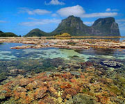
The main island of Lord Howe measures 10 km from north and south and is little more than 2 km in width. It roughly describes a crescent, enclosing a coral reef lagoon on its south-western side. The island's topography is dominated by the southerly Mount Gower and Mount Lidgbird. Only a narrow isthmus of lowland country in the north-central part of the island is habitable. The northern tip consists of steep hillsides culminating in extensive sea cliffs against the northern coastline.
 |
| Lord Howe Island Group |


