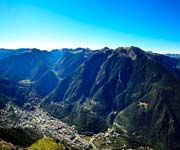
Cultural landscape of Madriu-Perafita-Claror Valley
The cultural landscape of Madriu-Perafita-Claror Valley offers a microcosmic perspective of the way people have harvested the resources of the high Pyrenees over millennia. Its dramatic glacial landscapes of craggy cliffs and glaciers, with high open pastures and steep wooded valleys, covers an area of 4,247 ha, 9% of the total area of the principality. It reflects past changes in climate, economic fortune and social systems, as well as the persistence of pastoralism and a strong mountain culture, notably the survival of a communal land-ownership system dating back to the 13th century. The site features houses, notably summer settlements, terraced fields, stone tracks and evidence of iron smelting.
Madriu-Perafita-Claror Valley

It has maintained intact its structures of organization and management of space since medieval times. Since then there has been no substantial alteration of the geopolitical and territorial model, which is why it has come down as a living witness to the history of Andorra and the coexistence between the men of the mountains and an extraordinary natural environment.

UNESCO Criterion
Criterion (v): The Madriu-Perafita-Claror Valley is a microcosm of the way its inhabitants have harvested the scarce resources of the high Pyrenees over the past millennia to create a sustainable living environment in harmony with the mountain landscape. The Valley is a reflection of an ancient communal system of land management that has survived for over 700 years.
Natural gifts of the valley
The most striking natural heritage elements are the glacial geomorphology (U-shaped valley, glacial circuses, the lake system of Gargantillar-Els Estanys, Estany de la Nou, rock glaciers, the hanging valley of Estany Blau, etc.), the post-alpine plateaux of Calm de Claror, the dynamics of avalanches, the vegetation associated with water (wet moorlands and peat bogs, riparian woodland, etc.), and various threatened vertebrate species (bearded vulture, capercaillie, ptarmigan, Tengmalm's owl, dotterel, Pyrenean desman, etc.). The lichens of the circus of Estanyons have served to obtain the first dating of the Little Ice Age in the Eastern Pyrenees, showing the relevance of this cold period to European history.
Like most of the territory of Europe, the valley is not virgin land. Man has used it, crossed it, and enjoyed it for centuries, moulding a landscape in which his imprint is everywhere present. The main historical uses of this zone were farming (tillage, animal husbandry, forestry), iron working and hydroelectric power. As a result, numerous human elements have survived to make up the cultural landscape of the valley. The structure of the vegetation has also been modified by all these activities, the imprint of which can be read indirectly from meadows sited on forest land, terraces made on steep slopes, or birch woodland replacing old-growth pine.

The cultural heritage elements of the site
The cultural heritage elements linked to traditional farming are the best represented: barns (Ràmio, Entremesaigües), terraces, shepherds' huts, sheep pens, drystone walls, milking stalls, etc., and a network of irrigation ditches in tillage zones. The remains of the Forge of Andorra (at an altitude of 1,900 m), the mines at La Maiana and Claror and the numerous charcoal-making sites in the woods bear witness to iron working. The use of hydroelectric resources began in the 1930s, generating its own infrastructure with two dams (L'Illa and Ràmio) and an underground conduit linking Ràmio to the lake at Engolasters. The stone path of the Madriu links all these activities, at the same time a symbol of and unique witness to the presence of man in the valley and forms one of the most characteristic and outstanding values of this cultural landscape. Source
Visit all Indian UNESCO Heritage Sites


