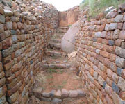
Khami Ruins National Monument is located to the west of the Khami River, 22 km from the City of Bulawayo. The property, located on a 1300 m hilltop downstream from a dam built during 1928-1929, covers an area of about 108 ha, spread over a distance of about 2 km from the Passage Ruin to the North Ruin. The property was the capital of the Torwa dynasty, which arose from the collapse of the Great Zimbabwe Kingdom between 1450 -1650 and was abandoned during the Ndebele incursions of the 19th century. It is composed of a complex series of platforms of dry-stone walled structures, emulating a later development of Stone Age culture. The chief's residence (Mambo) was located towards the north on the Hill Ruin site with its adjacent cultivation terraces. The population lived in daga huts of cobwork, surrounded by a series of granite walls.
Continent: Africa
Country: Zimbabwe
Category: Cultural
Criterion: (III)(IV)
Date of Inscription: 1986
Khami, the stone built monument
The structures display a high standard of workmanship, a great number of narrow passageways and perambulatory galleries and impressive chevron and chequered wall decorations. Khami conforms to Great Zimbabwe in a number of archaeological and architectural aspects but it possesses certain features particular to itself and its successors such as Danangombe and Zinjanja. Revetments or retaining walls found expression for the first time in the architectural history of the sub-region at Khami, and with it were elaborate decorations; it still has the longest decorated wall in the entire sub-region. Khami is the second largest stone built monument in Zimbabwe.
 |
| Khami Ruins National Monument |
Browse Gallery Plus UNESCO Storyline
Historic Specifications
The architecture of the site and the archaeological artefacts provide evidence for an exceptional understanding of strong, united, early civilizations. They also offer information on the property's complex socio-economic, religious and spiritual significance for the local communities and for the overall chronological development of Zimbabwe tradition; initiated in Mapungubwe (South Africa), extending to Great Zimbabwe, and through the emergence of later states. The archaeological remains are also a testament to long-distance historic trade links with the Portuguese, and the wider world, the diverse range of imported artefacts provide evidence of 15th and 17th century Spanish porcelain, Rhineland stoneware and Ming porcelain, many of which are on display in the Museum of Natural History in Bulawayo. There is also a monumental granite cross which illustrates the contact with missionaries at a traditionally revered and sacred spiritual site.
Its historical importance lies in its position at the watershed between the history of Great Zimbabwe and the later Zimbabwe period. It is one of the few Zimbabwe sites that were not destroyed by treasure hunters and its undisturbed stratigraphy is scientifically important in providing a much clearer insight into the history of the country. The climate supports a natural vegetation of open woodland, dominated by Combretum and Terminalia trees. Being close to the Kalahari Desert, the area is also vulnerable to droughts, and rainfall tends to vary considerably. The property has suffered some degradation due to variations in temperature, ground water, tourism, encroaching vegetation and applied preservation techniques.
Browse All UNESCO World Heritage Sites in
Zimbabwe. The original UNESCO inscription
Here!!!


